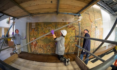
A 400-year-old tapestry map that depicts a mysterious event that happened among the villages, streams and windmills of Elizabethan Worcestershire is to go on public display for the first time in centuries at Oxford’s Bodleian library.
Exactly what happened, somewhere north of Kynaston and south of Edgbaston, in the 1590s remains a mystery, but the tapestry’s woven text is emphatic: the hilly landscape, near a village ominously named as “The Worldesend”, “was dryven downe by the removyng of the ground”.
“Earthquake? Landslide? Quarrying? We just don’t know,” says Nick Millea, map librarian at the Bodleian. “It’s one of the many things in this map I’d love to follow up one day.”
The map was made in the 1590s for a landowner called Ralph Sheldon, whose own grand house at Weston, near Long Compton, bristling with towers and Tudor chimneys, is represented as the size of a small town. It has been in the Bodleian, part of one of the largest map collections in the world, since it was bequeathed in 1809 with a companion map of Oxfordshire.
The Bodleian has been desperately short of space since it opened its doors in 1602, and never had a wall big enough to display the map. It therefore spent a century in store in Oxford, and then another century in borrowed storage space at the V&A in London.
The map has finally come out into carefully filtered daylight, its colours glowing as if it was woven yesterday, after a gentle bath in Belgium and a year of tender hand stitching conservation work at the National Trust’s textile workshop in Norfolk.
It will be exhibited in the Bodleian’s renovated 1934 listed storage building, an important – if hideous – design by Giles Gilbert Scott. Intended to hold 5m books, and to solve the storage problem forever, it was judged 130% full by the time it closed for the rebuild.
The £80m remodelling of the Gilbert Scott building by Wilkinson Eyre architects has created new bookstacks, beautiful new reading rooms, a conservation workshop, a cafe, and permanent display spaces for the library’s treasures for the first time, including a gigantic glass case for the map.
The marvels in the opening exhibition will include one of the library’s four copies of Magna Carta; the Shakespeare First Folio – the library had to buy it back at enormous expense in 1905 after a 17th-century librarian disposed of it when he acquired a copy of the much smarter Third Folio; relics of the poet Percy Bysshe Shelley including a lock of his hair; and the 16th-century Aztec Codex Mendoza, which was being sent back to Spain when it was captured by French pirates.
Even in such company, the map has been stopping people in their tracks as it was installed. “It was just like that in our workshop,” conservator Pip Sanders said, “we’ve never had a tapestry that people loved so much. Everyone spots some place name that has personal relevance for them.”
The mysterious “dryven downe” land is unlikely to be invention. Given that it was made when few people had ever seen even a paper map – Millea says that Sheldon would certainly have had to explain to most visitors what a map was and how to read it – the glowing landscape is remarkably accurate. Towns and villages, rivers and streams, beacons and windmills, stone and timber bridges, spires and square stone towers, forests and orchards, castles and cathedrals, even the prehistoric Rollright Stones circle are shown.
Although it has suffered severe damage, losing half its beautiful borders and possibly a third of its original size, the colours are still so brilliant that Sanders thinks it must have been in storage and protected from light for most of its long life.
One of its many delights is the text: one section says, of a county still famous for its orchards: “hear goodly orchards planted are in fruite which doo abounde. Thine eye wolde make thin hart rejoyce to see so pleasant grounde.”
It was originally one of four maps, showing the counties around Sheldon’s home, which presumably lined the walls of one huge room. It is thought to have been woven in England, possibly even in Worcestershire, though work continues to try and identify the source of the dyes.
The place names were all taken from another landmark in the history of topography, the first published county-by-county atlas of England, but that is just a large book, with a standardised set of symbols representing towns and other features. Millea has no idea where the weavers got the extra information about tall spires, walled towns and fenced hunting parks, to fill their space.
The work goes on: the companion map of Oxfordshire – which is in a sadder state, with a gaping hole where somebody cut a chunk out to make a firescreen – has already been booked into the textile studio. The surviving fragment of Gloucestershire which the Bodleian managed to acquire eight years ago is next in the queue. Millea will worry about where on earth to put them when the conservation work is complete.

